Member's BLOG: Tuesday, April 29th, 2014 >Check In<


....Hello,
 everyone ?


Monte Carlo Friends
to your
Member's `Blog
Tuesday, April 29th, 2014

What are you doing Today ?
What are you doing to your Monte Carlo ?
* Members, post what is happening in your life/family, your hobbie's, cars, etc.
* The MCF is here for you * 7/24 *
New Member's
Make a post & become a part of our
Monte Carlo Family
The MCF is a StressFree-Fun-Automotive Family Zone
Please don't hurt
 with your words/post!
 Your words paint the picture of you in the minds of the readers!
Give Respect to `Member's - Get Respect from `Member's
If you have not read our MCF Rules ?
Please click below link to enjoy your MCF experience
-> Please Read - Thank You! - Monte Carlo Forum - Monte Carlo Enthusiast Forums
^`Click ^
April 2014

Winner

Tadcaster
Congratulations Tadd
Mason, Michigan

^ 2006 Monte Carlo S.S. "Lil Deuce Coupe" ^
- Monte of the Year Winner 2013 -

^ 2004 Chevrolet Supercharged Street-Show-Racing Monte Carlo S.S. ^
Owner: Brent Nichol
Congratulations `Brent
London, Ontario Canada
\* Thanks to our Super MCF Staff for everything they do for us*(unpaid - all volunteer's).
Thanks`Lou (Taz) Our MCF Former Chief Administrator that donated
and gave so much of his time/life to rebuild, maintain & make our forum the best.
He selected two great administrator's to take his position;
Our New >MCF Administrators >(ChibiBlackSheep `Mike & The_Maniac `Jason)
We are thankful that `Lou (Taz) remained on the MCF as a Moderator/Advisor.
Thanks to all our members for your contributions to your MCF.
Any member can start our Member's Blog after midnight (12 AM EST).
Just copy & paste & change the day/dates!
Today's Blog started by
a `Friend

Wish everyone a Safe
&
Happy New Day
EnJoy your `Journey of `Life
What `if ?

"Be Good 2 yourself > others"
Help those in need `if you can ?
Wish you, yes you > Peace & Happiness in `Life.
Last edited by BeachBumMike; Apr 29, 2014 at 04:04 AM.


Joined: Sep 2011
Posts: 3,635
From: Central Oklahoma

Thanks for the bday wishes yesterday guys. Worked 11 hours so I wasn't able to get on after I woke up to respond to the happy bday wishes.
Devin, for future reference, green on an SPC convective outlook denotes non-severe thunderstorms being likely. Slight/Moderate/High risks areas are not necessarily indicative of tornado threat. There was a High risk issued late last year for a wind threat associated with storms and a couple of moderate risks issued this year so far primarily a large hail threat. I always read the text that goes with the graphics for that reason. It will outline all the information indicated by the graphics, along with the corresponding risk factors for affected areas.
Granted, we all knew there was a tornado threat for yesterday, but just because SPC issues a moderate or high risk, it does not mean the tornado risk is there. Just some friendly advice from someone who's been tracking weather (especially severe weather) out here in Oklahoma for over two decades. If you have any questions, feel free to PM me.
I think I'm gonna watch the morning news and head for bed. Y'all have a good one.
") Hi Sgt. `Drew,
Hi Sgt. `Drew,I hope that you had a great birthday. It's good that you are getting so many hours @ work
 How has life been going for you ? How's you ride ?
You are getting older
 , but are you getting better ?
Joined: Sep 2011
Posts: 3,635
From: Central Oklahoma
Well last week I was told I was getting promoted to team lead which will mean more hours and better pay. The 78 Camaro will be getting a new transmission in the next month and then after that I'll start building a new motor for the 73. I'm busy but I've been good.
As far as feeling older, that happens everytime I get out of bed with my bad knee.
As far as feeling older, that happens everytime I get out of bed with my bad knee.


Thanks for the bday wishes yesterday guys. Worked 11 hours so I wasn't able to get on after I woke up to respond to the happy bday wishes.
Devin, for future reference, green on an SPC convective outlook denotes non-severe thunderstorms being likely. Slight/Moderate/High risks areas are not necessarily indicative of tornado threat. There was a High risk issued late last year for a wind threat associated with storms and a couple of moderate risks issued this year so far primarily a large hail threat. I always read the text that goes with the graphics for that reason. It will outline all the information indicated by the graphics, along with the corresponding risk factors for affected areas.
Granted, we all knew there was a tornado threat for yesterday, but just because SPC issues a moderate or high risk, it does not mean the tornado risk is there. Just some friendly advice from someone who's been tracking weather (especially severe weather) out here in Oklahoma for over two decades. If you have any questions, feel free to PM me.
I think I'm gonna watch the morning news and head for bed. Y'all have a good one.
Devin, for future reference, green on an SPC convective outlook denotes non-severe thunderstorms being likely. Slight/Moderate/High risks areas are not necessarily indicative of tornado threat. There was a High risk issued late last year for a wind threat associated with storms and a couple of moderate risks issued this year so far primarily a large hail threat. I always read the text that goes with the graphics for that reason. It will outline all the information indicated by the graphics, along with the corresponding risk factors for affected areas.
Granted, we all knew there was a tornado threat for yesterday, but just because SPC issues a moderate or high risk, it does not mean the tornado risk is there. Just some friendly advice from someone who's been tracking weather (especially severe weather) out here in Oklahoma for over two decades. If you have any questions, feel free to PM me.
I think I'm gonna watch the morning news and head for bed. Y'all have a good one.
With all do respect buddy, I do know what I'm talking about. appreciate the thought of trying to help me out, but yesterday was a tornado threat hence why people in the moderate to high risk had to keep an eye out for tornadoes yesterday. It was a hail and wind event as well i agree but large violent long lived tornadoes were the big killer yesterday that people had to keep an eye out for. there was plenty of CAPE and low level wind sheer in the moderate/high risk areas for tornadoes plus the cloud cover did clear up in the late mornings so with that sun out caused even more De-stablization in the atmosphere and some wedges were in those areas as well as 90 confirmed tornadoes so people need to take very much caution with tornado events. that's why i get the word out
not everyone is a weather nut here to i try to keep it as simple as possible, telling people in shaded areas to be careful is the best way.
Last edited by MnteCrloSS47; Apr 29, 2014 at 09:28 AM.
LoL `Devin, "With all do RESPECT" > I respect your words/knowledge & you 4 sharing & keeping your Monte Carlo Family informed on what's happening out there with Mother Nature.
I don't chase storms, but they seem to chase 'me (LOL)
=================================================
OK,it's time 2 get `up & dance > > & Celebrate `Life >4>Sure

I don't chase storms, but they seem to chase 'me (LOL)
=================================================
OK,it's time 2 get `up & dance >
> & Celebrate `Life >4>SureLast edited by BeachBumMike; Apr 29, 2014 at 05:50 AM.
Now with that all said, good morning everyone!
And today looks like another wild day for severe weather.
The tornado threat today is a bit less than the last 2 days but it is definitely still there for areas of northern Mississippi and southern Alabama.
Here are the areas where tornadoes could form.
green=2% tan=5% brown=10% blue -15% .
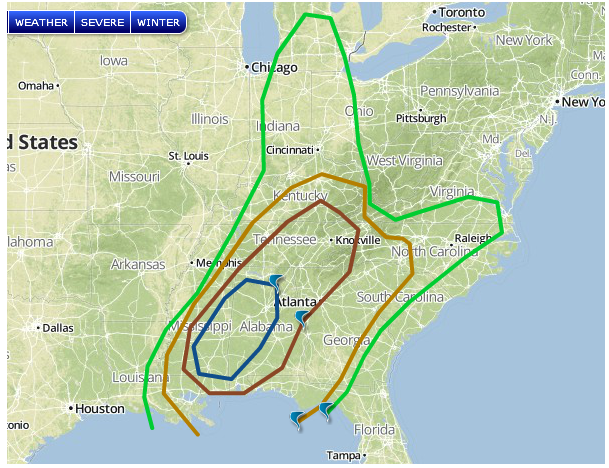
The rest of the area will be a wind/hail even with some very large hail possible

There is already 2 tornado watches up for a line of storms pushing east

looks like a rainy day for most the country today!

And today looks like another wild day for severe weather.
The tornado threat today is a bit less than the last 2 days but it is definitely still there for areas of northern Mississippi and southern Alabama.
Here are the areas where tornadoes could form.
green=2% tan=5% brown=10% blue -15% .
The rest of the area will be a wind/hail even with some very large hail possible
There is already 2 tornado watches up for a line of storms pushing east
looks like a rainy day for most the country today!