
Member's BLOG: Sunday, January 5th, 2014
#1
 01-05-2014, 02:29 AM


Join Date: Apr 2009
Location: Pittsburgh, PA
Posts: 11,978

Welcome

Monte Carlo Friends
to your
Member's `Blog
Sunday, January 5th, 2014

What are you doing Today ?
* Members, post what is happening in your life/family, your hobbies, cars, etc. We are here 24/7

Our active member's are the ones that keeps our forum growing.
Please make a post & become a active member & part of our
Monte Carlo Family
Thank You!
The MCF is a StressFree-Fun-Automotive Family Zone
Please don't hurt

with your words/post!
Give Respect to `Member's - Get Respect from `Member's
>Your words paint the picture of you<
If you have not read our MCF Rules ?
Please click the below link to enjoy your Monte Carlo Forum Experience
-> Please Read - Thank You! - Monte Carlo Forum - Monte Carlo Enthusiast Forums
January 2014

dbaldwin (David Baldwin)

* Special thanks to our MCF Administrators, our MCF Staff
& our active contributing 'members for their loyal dedication to the MCF
*Any member can start our MCF `Blog after midnight (EasternStandardTime)
Thank You!
Last edited by monte carlo 3831; 01-05-2014 at 03:05 AM. Reason: January spelling corrected above Monte of the Month
#2
01-05-2014, 02:35 AM
Join Date: Apr 2009
Location: Pittsburgh, PA
Posts: 11,978
Not much going on here, just got 1 more day off after being off since Tuesday the 31st..... Can't wait to work my first day this year.....
Keane, I see your selling the 97, good luck with that. I'm looking into letting my 99Z34 go soon also. It has some needs that I plan on getting fixed by spring or sooner? Maybe......
Keane, I see your selling the 97, good luck with that. I'm looking into letting my 99Z34 go soon also. It has some needs that I plan on getting fixed by spring or sooner? Maybe......


#4
01-05-2014, 04:34 AM


Monte Of The Month -- November 2012
Monte Of The Month -- June 2014
Monte Of The Month -- July 2016


Good morning all!
Cold morning for most!
Coldest it has been/going to be in 20 years!

current watches and warnings!

That snow in front of this cold front did start to kick off! From Oklahoma into Canada!
Current radar:

Some forecasts are saying up to 2" per hour will happen!

The SPC mesoscale discussion issued for central to eastern MO, for heavy snow and 1"-2" per hour snowfall rates into early afternoon, including St Louis area by daybreak.
Heavy snow band will then pivot northeastward toward the southern Great Lakes Region through the day, So michiganers/Canadians, This isn't the heavy stuff yet falling, that's to come Later today

stay safe everyone!

Cold morning for most!
Coldest it has been/going to be in 20 years!
current watches and warnings!
That snow in front of this cold front did start to kick off! From Oklahoma into Canada!
Current radar:
Some forecasts are saying up to 2" per hour will happen!
The SPC mesoscale discussion issued for central to eastern MO, for heavy snow and 1"-2" per hour snowfall rates into early afternoon, including St Louis area by daybreak.
Heavy snow band will then pivot northeastward toward the southern Great Lakes Region through the day, So michiganers/Canadians, This isn't the heavy stuff yet falling, that's to come Later today
stay safe everyone!
Last edited by MnteCrloSS47; 01-05-2014 at 04:45 AM.
#5
01-05-2014, 05:01 AM
Monte Of The Month -- November 2012
Monte Of The Month -- June 2014
Monte Of The Month -- July 2016
Wow, I've never seen this before
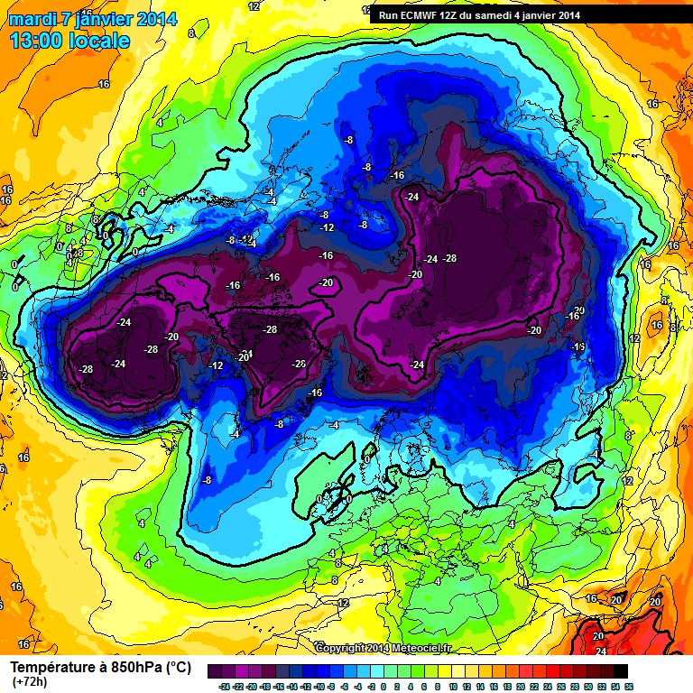
Now that's cold! right here in the USA/Canada is going to be one of the Coldest places on earth Monday! With some places seeing temps at -18 degrees F! without windchill!
Now that's cold! right here in the USA/Canada is going to be one of the Coldest places on earth Monday! With some places seeing temps at -18 degrees F! without windchill!
Last edited by MnteCrloSS47; 01-05-2014 at 05:04 AM.
#6
01-05-2014, 05:08 AM

Morning all, yea Chris its ready to throw a rod at any time now so Im trying to sell it while it still moves under its own power.
#7
01-05-2014, 06:05 AM


")
Good Morning Taz >'Lou,
Today is my last day on the MCF
 . I leave by boat early tomorrow morning to join 'Space on the islands. Florida has freeze warning for Tuesday morning It's cold everywhere.
Wish you a super 2014.
I'm looking forward to this adventure/job

Hi 'Keane, sorry 2 read 'bout your Monte
That's uncalled for 4>Sure (j/k) Good luck on your sale & in life.
* Hi 'Chris, thanks for starting the MCF 'Blog. It's great that you are looking forward to going back to work (?)

 p.s. > So am I (LOL)
* Hi Devin, thanks for the MCF Weather Report. I'm so thankful that I am escaping the cold weather & going further south (LOL)
Wish you & everyone a great New Day & New Year 2014


Peace/Out Bum'Mike
Last edited by BeachBumMike; 01-05-2014 at 06:23 AM.
#8
01-05-2014, 07:07 AM


Join Date: Aug 2008
Location: London, Ontario
Posts: 5,611
Mornin' folks!
I like this map...
If it is correct, all the harsh weather should stop right at the border! Its looking like its going to be a rather gray day in Canada, but I'll take it over the freezing and snow that is south of the border!
I like this map...
If it is correct, all the harsh weather should stop right at the border! Its looking like its going to be a rather gray day in Canada, but I'll take it over the freezing and snow that is south of the border!
#9
01-05-2014, 07:12 AM
Monte Of The Month -- November 2012
Monte Of The Month -- June 2014
Monte Of The Month -- July 2016
#10
01-05-2014, 07:20 AM

Join Date: Aug 2011
Location: Ann Arbor, Michigan
Posts: 4,781
Good morning guys. Cool graphics Devin.
Snow has started falling here within the last couple hours. Areas to the North of here in the M-59/I-69 corridor where it has been snowing overnight have already reported accumulations up to 5.5" as of 8 AM EST.
National Weather Service predictions show anywhere from 7-14" of snow in the area highlighted below through 1 AM EST Monday morning. Snow becomes heavy this afternoon into evening; predictions show an 80-100% chance of achieving a 1"/hr snowfall rate and, likewise, a 10-45% chance of achieving a 2"/hr rate of snowfall. Additional light accumulation of <1" is expected through the day Monday.
NWS Detroit/Pontiac's total snow accumulation prediction for SE MI and Tri-Cities

Current radar

Snow has started falling here within the last couple hours. Areas to the North of here in the M-59/I-69 corridor where it has been snowing overnight have already reported accumulations up to 5.5" as of 8 AM EST.
National Weather Service predictions show anywhere from 7-14" of snow in the area highlighted below through 1 AM EST Monday morning. Snow becomes heavy this afternoon into evening; predictions show an 80-100% chance of achieving a 1"/hr snowfall rate and, likewise, a 10-45% chance of achieving a 2"/hr rate of snowfall. Additional light accumulation of <1" is expected through the day Monday.
NWS Detroit/Pontiac's total snow accumulation prediction for SE MI and Tri-Cities
Current radar
Last edited by 06mistreSS; 01-05-2014 at 01:20 PM.